
Robert
Bike
Licensed
Massage Therapy #5473
Eugene, Oregon
EFT-CC, EFT-ADV
Teaching Reiki Master
Life Coach
541-465-9486
![]()
Gift Certificates
|
Reiki
Private classes. |
|
Member
OMTA & ABMP President of the Oregon Massage Therapists Association 2008-2010 & 2012-2013 |
|
I
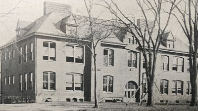
graduated from Freeport (Illinois) High School. |
|
Please
help keep
this site free. Buy one of my books, on sale below. All sales go to help support this website. |
|
Remarkable
Stories,
Remarkable
events have happened in Freeport and Stephenson County, Illinois,
and remarkable people have lived there. These are stories gathered
about people and events from 1835 through World War II. |
|
Biblical
Aromatherapy
by Robert Bike 
The Bible mentions about 232 plants by name, or closely enough to figure out what plant is meant. Of these, 24 are aromatic plants; that is, parts of the plants can be pressed or distilled to get an essential oil. Essential oils are the lifeblood of plants and have tremendous healing capabilities. The
healing power of plants is the basis for modern medicines.
Originally published in manuscript form in 1999, I completely revised the book and added illustrations. To order
Biblical Aromatherapy in paperback, List price $24.99; introductory offer $19.99 To order the pdf version and download to your computer or phone, The electronic version is only $2.99! |

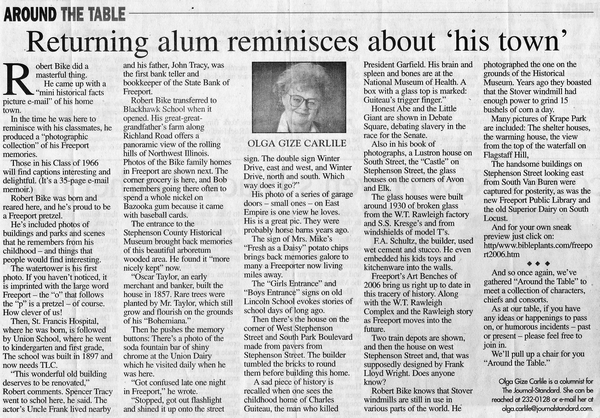
Publicity!
|
Olga
Carlile, columnist for the Freeport (Illinois) Journal Standard,
featured this website in her column on January 19, 2007. |
|
Harriet
Gustason, another columnist for the Freeport Journal Standard,
has featured this website twice. Click to see pdf of articles:
June 29, 2012 November 3, 2012 |
|
"My
Life Purpose is to inspire my friends |
Robert Bike, LMT, LLC
The Class of 1894
Robert Best, attended college in Minneapolis, Minnesota; physician, Chicago.
Minnie Blosser, stenographer, Freeport.
Clara Dorman, Freeport.
Emily Frick, stenographer, Freeport; later a teacher in Freeport.
Emmaretta Henderson, clerk in German Insurance office, Freeport.
Etta Huenkemeier, attended college in Madison, Wisconsin; married Mr. Beckmier, Freeport.
Alice Mattert, bookkeeper, Freeport.
Susie Meyers, stenographer, Freeport.
Philip Moogk, clerk, Chicago; later Assistant Supervisor at Reno Electric Light & Power Co., Sparks, Nevada.
Weard Penning, Freeport.
Mildred Pfender, bookkeeper, Freeport; married classmate Robert Stibgen, Britt, Iowa.
Elta Potthast, attended Normal school, Milwaukee, Wisconsin; later Madison.
William Shuneman, Freeport.
Theron Skeel, with Robinson Manufacturing Company, Freeport.
Bertha Staver, Freeport; later married Mr. McCall.
Katherine I. Stevens, teacher, Freeport; later Chicago.
Robert Stibgen, clerk, Freeport; married classmate Mildred Pfender, Britt, Iowa.
Bertha Taylor, Freeport; later on a fruit farm in California.
Louis Voigt, attended college, Evanston, Illinois; physician, Freeport.
Emma Walz, stenographer, Freeport; later a teacher in Freeport.
Regina Weisher, married Mr. Coltman, Omaha, Nebraska; later Chicago.
Louise Whiteside, Freeport; married Mr. Wilson, Fargo, North Dakota.
Alys Wilson, Chicago; later married Mr. McCloud.
The Freeport High School football team played its first game in the fall of 1893, but lost to Rockford. W. D. Hanks, the FHS principal, was the coach. Team members were George Zeiders, Charles Ascher, Ralph Mayer, Louis Voigt, Philip Moogk, Lynn Griffith, Theron Skeel, Will Wright, Weard Penning, Lalon Hayes, Charles Freeman and LeRoy Laird.
I inherited my great-grandfather's 1894 Plat Book. William Peter Bike (1853-1936) farmed 80 acres in Buckeye Township, Stephenson County, Illinois. He bought the farm from his father-in-law, Adam Epley, Sr. (1820-1894), my great-great grandfather.
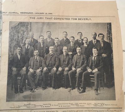
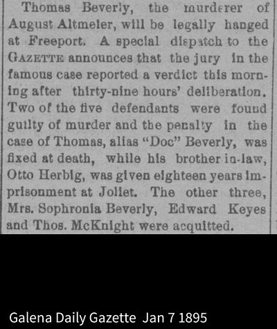
In between the pages of my great-grandfather's 1894 Plat Book was this clipping. The photo shows the jury in the front two rows, and the legal team in the back row.
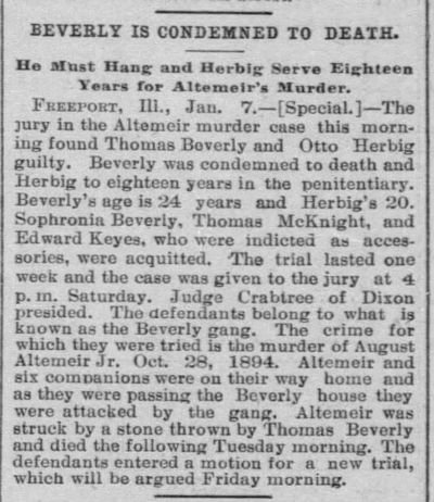
After 29 hours of deliberation, the jury found Thomas Beverly, 24, and Otto Herbig, 20, guilty. Beverly was sentenced to be hanged, while Herbig got 18 years in Joliet. The victim was August Altemeier, 24, who left behind a young wife, Frieda (1870-1962) and 1-year old son, Edward (1893-1987). Three others were acquitted.
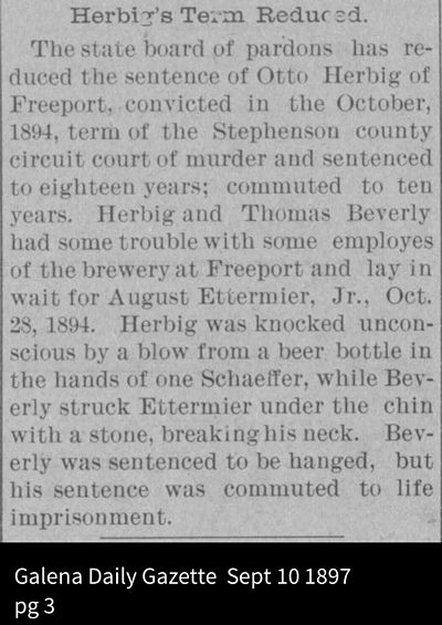
Thomas Beverly's sentence was commuted to life imprisonment, and he reportedly died in prison. Otto Herbig's (1874-1917) sentence was reduced to 10 years.
The back side of the Tom Beverly jury photo is also interesting. It shows the tax payments of Freeporters who paid more than $75. German Insurance paid the most for any corporation, while William Walton topped the individual list.
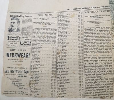
The column on the right talks about a new normal school to be built in Illinois. A normal school is a teacher's college. The writer contends that Freeport is an ideal choice, and that Bailey's Park, owned by Judge Bailey is the best place.
Dekalb won the bid for the school, and it was called Northern Illinois State Normal School, and it became Northern Illinois University..
Also, the advertisement is for Hood's Sarsaparilla Pills to cure your liver ills, only 25 cents!
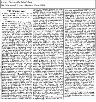
Judge Joseph Meade Bailey (1833-1895) owned a plot of land south of the Oscar Taylor property, now the Stephenson County Museum, in which he hand-planted most of the trees. It was a privately owned park where families often gathered for picnics and relaxation. Judge Bailey offered it to the city of Freeport for a very fair price, but the city, lacking a parks department, failed to buy it at least twice. After his death, his wife, Anna Bailey (1833-1928), tried to sell it to the city for a park, but also failed. Developers bought the park, and it became Bailey's Park Subdivision, shown below in the 1913 Plat book.

Judge Bailey came to Freeport in 1856 from New York where he graduated from the University of Rochester at the top of his class, and immediately began practicing law. In 1867 he was elected to the Illinois House of Representatives. He was appalled by the graft and corruption he found there.
He introduced and got passed a law that required corporations be subject to future laws by the legislature. He also got passed laws that related to the competency of witnesses, the adoption of minors, and the maintenance of married women.
At that time prisoners at the state penitentiary at Joliet were leased to private interests and forced to work without pay, slavery, for the controlling companies. The inmates were poorly fed and often beaten. Judge Bailey put the penitentiary under a state commission that forbade beatings.
He sponsored creation of the juvenile justice system and a reform school for prisoners ages eight to eighteen. He authored laws differentiating levels of theft, petty larceny and grand theft.
Judge Bailey saw that the Illinois constitution was inadequate and got a new constitution passed in 1870. He then retired from the legislature and built up a large private practice.
In 1876 he was chosen for the Circuit Court. In 1877 he was chosen for the Appellate Court. He encouraged better education and a strong test to pass the bar, and was instrumental in organizing the Chicago Evening School of Law, and was dean of the school until his death. He was also a trustee at the University of Chicago and Lake Forest University.
In 1888, Judge Bailey was elected to the Illinois Supreme Court, where he wrote many decisions affecting Illinois law. When he died in 1895, the courts adjourned, and special trains brought mourners to Freeport for his funeral. He and Anna are buried in City Cemetery.
This 1888 history of Bailey's Park was provided by Steve McMillen.
This close-up of the northernmost part of Silver Creek Township in 1871
shows Bailey's land abutting the Oscar Taylor estate (directly under
the R in Range).
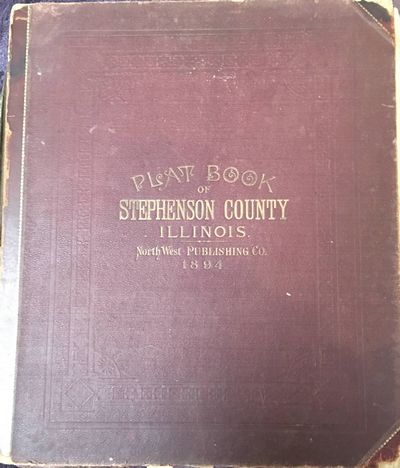
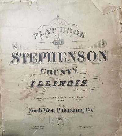
Plat Book of Stephenson
County Illinois
NorthWest Publishing Co.
1894
This is the 1894 Stephenson County Plat Book. It belonged to my great grandfather, William Bike, who farmed in Buckeye Township.
_tn.jpg)
Title Page
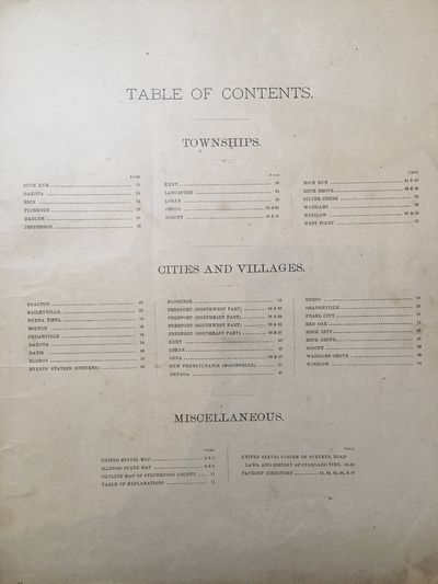
Table of Contents
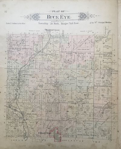
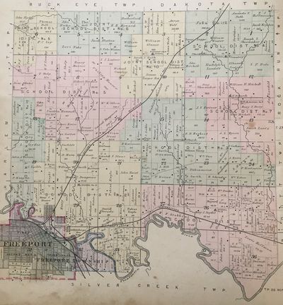
Both the 1913 Plat Book which I posted on my 1913 page and this Plat Book are large format books. They are 15 inches wide by 18 inches high. This is Buckeye Township, located north of Cedarville. Each township is platted out by the square and conveniently have numbers to help locate farms. The town of Buckeye is approximately in the center of the township. The Plat Book shows a Buckeye post office and a Buckeye town hall. There are just farm buildings there now.
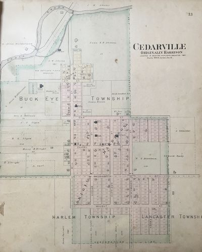
Cedarville in 1894
In the upper left is the John Addams estate, clearly showing the grist mill and the mill race off of Cedar Creek. John Addams bought the property, including the mill, from Conrad Epley, who happens to be my great-grandmother’s brother.
Part
of the foundation of the grist mill is still visible. It is on private
property, so if you want to see it, go to the Jane Addams homestead
and ask permission.
Just above the words Buck Eye is the Cedarville school. It is now a very nice museum.
This is the northwest corner of Buckeye Township. Located at number 10 on the map is the farm of Daniel Wagner, one of my great grandfathers. He was a cabinet maker who came from Pennsylvania. I have one of his pieces. He also had a very large bee and honey operation. And just north of Daniel Wagner is August Wachlin, another of my great-grandfathers.
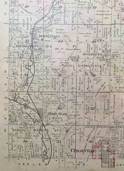
This is the southwest corner of Buckeye Township. Located at number 23 is the farm of William P. Bike, my great grandfather, who owned this plat book.
This is the northeast quarter of Buckeye Township. At number 18 is my great grandmother‘s brother, Adam Epley. And across the road is W. H, Matter, who moved to a house on North Harlem when he retired, referenced in a 1913 post.
And this is the southeast quadrant of Buckeye Township. On this map in Section 19 we see John E. Bike—my great-grandfather's brother.
I once lived just east of Scioto Mills in a haunted farmhouse that has since been torn down. It used to be called Sciota Mills, but the post office made them change the name because of identical spelling issues. This is the northeast quarter of Harlem Township with Sciota Mills in the middle.
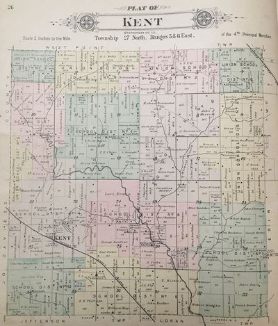
Kent Township, straight west of Freeport, bordering the Jo Daviess County line. West Point Township is on the north edge, Erin Township is to the east, and Jefferson and Loran Townships are to the south.
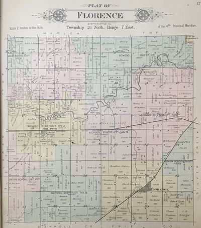
Florence Township, just southwest of Freeport. Loran Township borders the west, Harlem Township is on the north, Silver Creek Township is on the east, and the south border includes both Carroll and Ogle Counties.
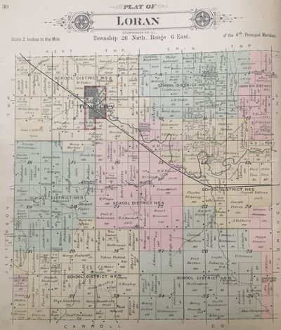
Loran Township, west-south-west of Freeport. Jefferson Township borders the west, Kent and Erin Townships border the north, Florence Township is to the east, and Carroll County is the south border.
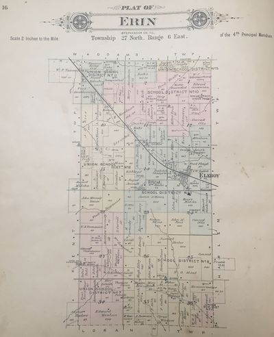
Erin Township, west of Freeport. Kent Township is to the west, Waddams Township is on the north, Harlem Township is to the east, and Loran Township is on the south border.
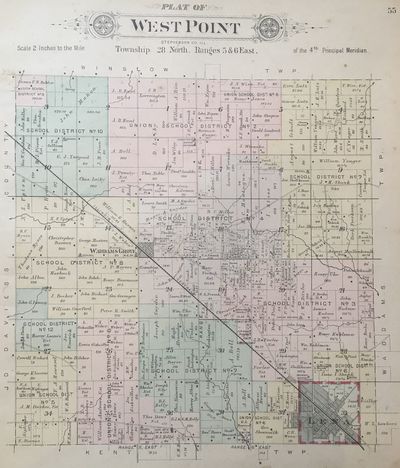
West Point Township, northwest of Freeport. Jo Daviess County borders the west, Winslow Township is on the north, Waddams Township is on the east, and Kent Township is on the south. Lena is in the southeast corner, and Waddams Grove, the oldest settlement in Stephenson County, is in the center of the township.
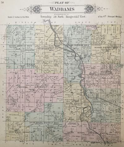
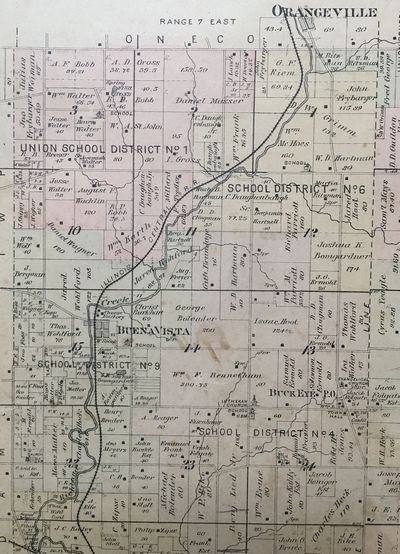
Waddams Township, northwest of Freeport. West Point Township is to the west, Winslow and Oneco Townships to the north, Buckeye Township is to the east, and Erin and Harlem Townships are to the south.
Ridott Township, southeast of Freeport. Ridott Township is bordered by Winnebago County on the east, Ogle County on the south, Silver Creek and Lancaster Townships on the west, and Rock Run Township on the north.
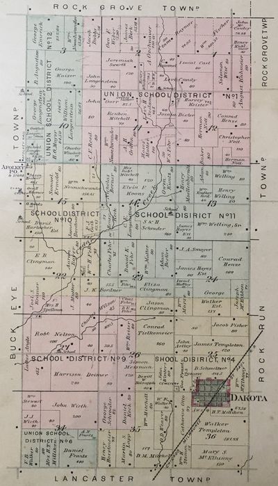
Oneco Township, north of Freeport. Oneco Township is bordered by Wisconsin on the north, Rock Grove Township to the east, Buckeye and Waddams Townships to the south, and Winslow Township to the west.
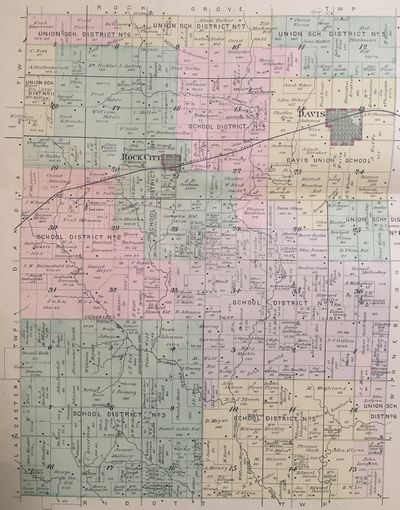
Rock Run Township, northeast of Freeport. It is bordered on the east by Winnebago County, the south by Ridott Township, the west by Lancaster and Dakota Townships, and the north by Rock Grove Township.
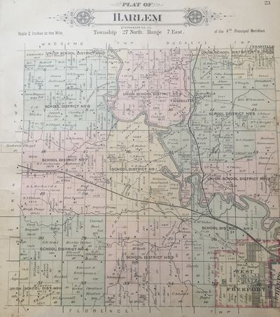
Harlem Township, northwest of Freeport. It is bordered on the west by Erin Township, the north by Waddams and Buckeye Townships, the east by Lancaster Township and Freeport, and the south by Freeport and Florence Townships.
Dakota Township, northeast of Freeport. It is bordered on the north by Rock Grove Township, the east by Rock Run Township, the south by Lancaster Township, and the west by Buckeye Township.
Lancaster Township, northeast of Freeport. It is bordered on the west by Freeport and Harlem Township, the north by Buckeye and Dakota Townships, the east by Rock Run and Ridott Townships, and the south by the Pecatonica River, Silver Creek Township, and Freeport.
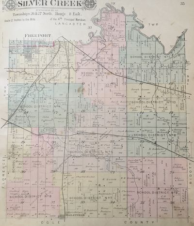
Silver Creek Township, southeast of Freeport. It is bordered on the north by Freeport, the Pecatonica River and Lancaster Township, on the east by Rock Run and Ridott Townships, the south by Ogle County, and the west by Florence Township and Freeport.
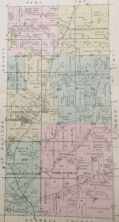
Jefferson Township, southwest of Freeport. It is bounded on the south by Carroll County, the west by Jo Daviess County, the north by Kent Township, and the east by Loran Township.
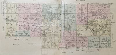
Rock Grove Township, northeast of Freeport. It is bordered on the north by Wisconsin, the east by Winnebago County, the south by Rock Run and Dakota Townships, and the west by Dakota and Oneco Townships. It is the only township with a panhandle.
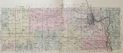
Winslow Township, northwest of Freeport. It is bordered on the west by Jo Daviess County, the north by Wisconsin, the east by Oneco Township, and the south by Waddams and West Point Townships.
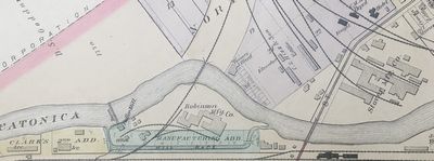
Manufacturers Island, located northwest of the Stephenson Street bridge across the Pecatonica River. The "island" is formed by the mill race and the Pec. This portion of the Freeport Plat Map clearly shows the dam, the mill race, and Manufacturers Island.
On Manufacturers Island we can see Robinson’s buggy factory, the Roller Mill, an office, and some other small buildings.
Upstream from the dam are a couple of ice houses.
Across the river is the J. Ward Tannery, C. S. Hizz & Son Elevator and office, the Chicago, Milwaukee and St. Paul Railroad (commonly called the Milwaukee Road) depot and freight office, a hotel, oil storage and the Stover Manufacturing Company.
A railroad bridge crosses the river in the center of the map, and to the right of center is the Stephenson Street bridge.
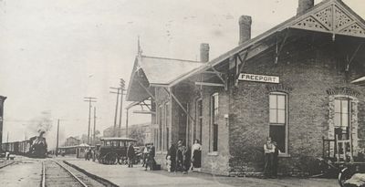
The Milwaukee Road depot. This building was torn down and a second one built. The second one is still standing, though at this writing without a roof.
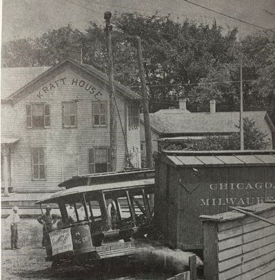
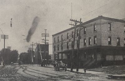
The Kraft House Hotel next to the Milwaukee Road station was opened in 1860 by A. C. and Edward Kraft. It closed in 1914. The hotel in the bottom photo was on the south side of Stephenson, and top one was on the north side.
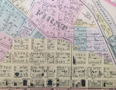
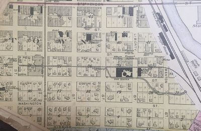
Downtown Freeport north of Stephenson Street in the 1894 Plat Book.
At the top right you can see the ice houses and the canning factory.
There is a brewery on Oak Place/Monterey Street.
Clay Street is now Douglas and we can see the Clifton Hotel at the corner with Chicago.
At Stephenson and Adams is the Salvation Army barracks.
The Brewster Hotel is on the corner of Stephenson and Mechanic/State Street. There is another hotel west of the Brewster house with two banks on the corner of Stephenson and Chicago.
There are three banks, the opera house and the courthouse at the corner of Stephenson and Van Buren.
There is a livery on Exchange across from the courthouse and county jail.
We can see First Ward school at the corner of Exchange and Cherry.
The fire engine house is on the corner of Stephenson and Walnut but is only a half block deep.
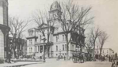
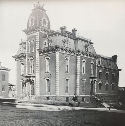
The Stephenson County Courthouse.
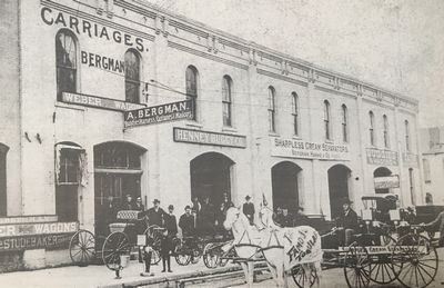
The buildings across Exchange Street from the courthouse.
A. Bergman — Buggies, Harnesses, Carriages & Wagons; Studebaker Carriages
Henney Buggy Company
Sharpless Cream Separators
Buggies and Wagons
Farm Equipment
Info from Steve McMillen: From the 1905 city directory: Even (north) side of Exchange St. from Van Buren to Galena. Remember that numbering went from east to west. 122 Dorman & Co. (H. Dorman, H. F. Dorman, and J. F. Smith) farm machinery, wagons, and buggies. 136 W.F. Bergman & AE Hanke, dealers in agricultural implements and buggies. 138 Christopher J. Dittmar Livery. Dittmar was also the mayor in 1905.
The Stephenson County jail was built in the late 1870s and was destroyed by fire in 1962.
It also contained a residence for the sheriff and his family.
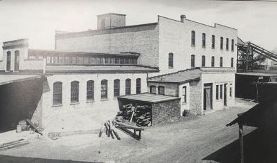
The Keene Canning Company, 1888–1953.
Robinson’s Novelty Carriage Works on Manufacturers Island.
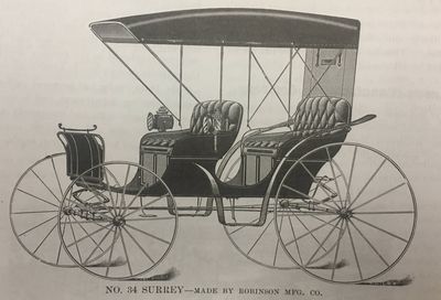
Here’s an example of a buggy made by Robinson Manufacturing Co. on Manufacturers Island.
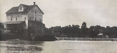
Here’s a nice photo of the dam on the Pecatonica River. Shown is Goddard and Clark’s Roller Mill. The dam washed out in 1931.
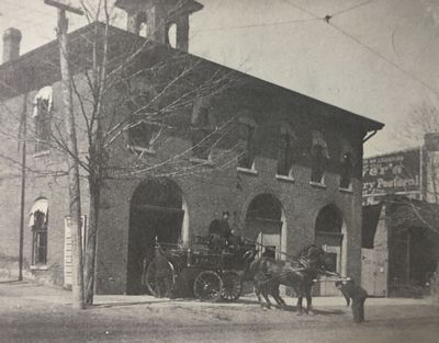
The old City Hall and fire engine house — 1868 to 1898.
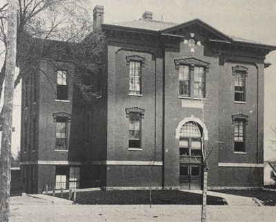
First Ward School was built in 1878.
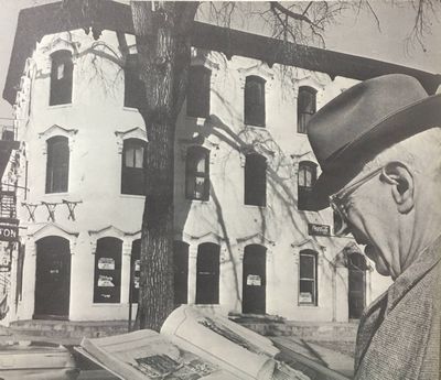
I love this photo of the Clifton House Hotel from the 1970 History of Stephenson County.
Shown is Leslie Fargher (1876-1979), a long time Freeport historian.
Ice for the ice houses was cut from the mill pond behind the dam on the Pecatonica River.
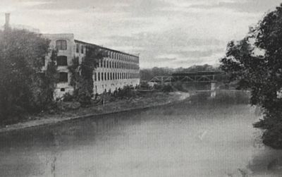
This photo was taken in 1895 and shows the north side of Goddard and Clark’s Roller Mill.
Downtown Freeport south of Stephenson Street.
Notable buildings are the Union Depot and Freight House.
Moving west, Bicycle Manufacturing Company, several hotels along Stephenson and Main. Also on Main, the Germania.
On Spring Street, Warren Manufacturing, a Planing Mill, the Vinegar Works, Freeport Bicycle Company, one of at least three Tobacco company buildings in Freeport’s history, Henney Buggy Company, and a Machine Shop.
On Jackson Street, Electric Light Works, Gas Works, and a brewery.
Spring Creek is visible flowing from near Adams and Spring into a culvert to the Pecatonica River.
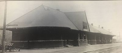
The Union depot.
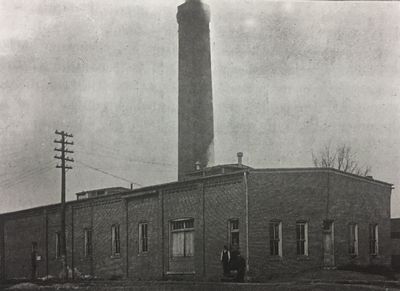
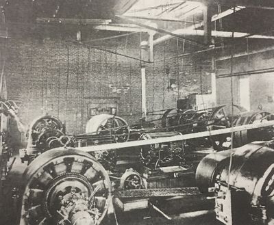
The General Electric Company generating plant and dynamo room, located at Jackson and Liberty.
Freeport produced its own electric through various companies from 1856 until 1931, when it became easier and cheaper to produce electricity for a large area, eventually consolidating under Commonwealth Edison.
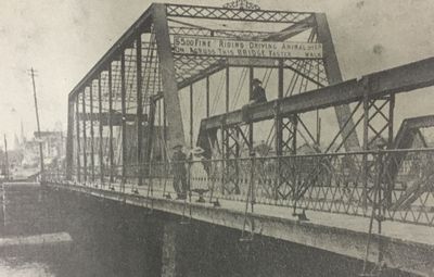
The Stephenson Street bridge, 1883-1901.
The sign on the bridge reads, “$5.00 fine for riding or driving animals over, on, across this bridge faster than a walk.”
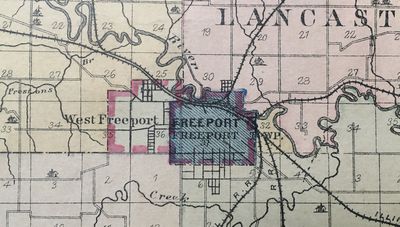
This is a close-up of the center of the 1894 Plat Book map of Stephenson County.
Shown is the city of Freeport, and its suburb, West Freeport. The village of West Freeport actually had its own governing body and existed completely separate from the city of Freeport.
Many people wanted to combine the two to consolidate services, but the wealthy people in West Freeport didn't want to pay Freeport's higher taxes, and the people of Freeport didn't exactly like combining the two. Combining the two towns came up for a vote in the 1890s, with a majority vote required in both towns to pass. Both Freeport and West Freeport soundly defeated the measure.
By 1907, taxes for services in West Freeport had grown to nearly equal that in Freeport; additionally Freeport agreed to build a fire station to serve West Freeport, and on April 1, 1907, both towns passed the annexation measure, and we got one Freeport.
The eastern border of West Freeport ran along the west edge of City Cemetery north to West Galena with Whistler Avenue as the dividing line, cut east to Railroad Avenue, then north to the Pecatonica River.
It ran south from the western edge of the cemetery to Empire, then west to about where Park Crest Drive is now, and north nearly to West Galena, where it zigzagged east and north to the river.
Many places there were no roads for boundaries, and sometimes it cut through farmers' fields.
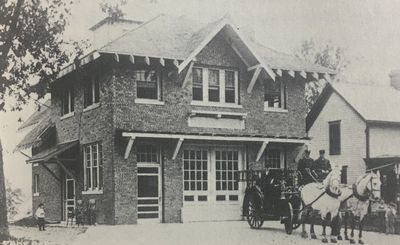
Freeport made good on its promise to West Freeport and built Fire Station Number 3 on West Lincoln Street, adjacent to City Cemetery, and just over the boundary to West Freeport.
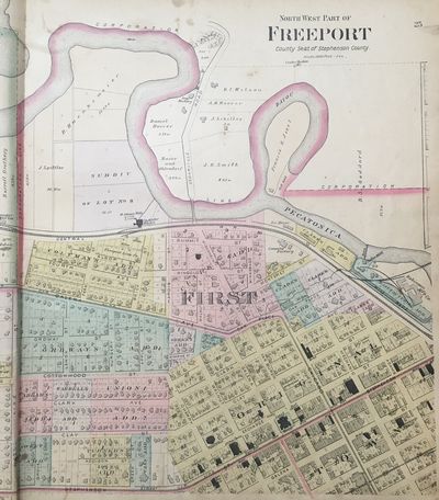
Northwest
part of Freeport
in the 1894 Plat Book
Wisconsin Street became N. Van Buren Avenue. The bridge there was the main route north to Cedarville and Wisconsin.
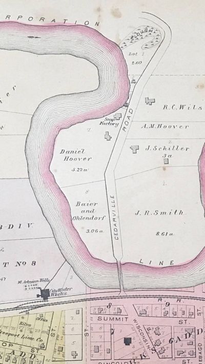
There is a soap factory on N. Cedarville Road. Daniel Hoover moved his soap factory to this location after two fires completely destroyed his business in Freeport in 1880. He employed four people to help him make 100,000 pounds of soap per year.
Ten artesian wells are shown at the City Water Works.
Freeport Lime Company is at Alsop and Brick, with kilns near the railroad track. Lime is extracted from limestone (calcium carbonate), through burning in the kilns. The ash is called quicklime and is the primary ingredient in mortar and cement, and is an important ingredient in glass.
Three lime quarries in the northwest part of Freeport were worked. The type of limestone here is the Galena, soft and crumbly at the top, getting progressively harder as it got worked deeper, worked to a depth of about 30 feet. A reddish clay that often overlays the lime makes excellent bricks, hence several brickyards in the area.
Almost all of the stonework in Freeport came from area quarries. The deeper Galena limestone is ideal for heavier kinds of masonry. It was extensively used for most building foundations, and several of Freeport's large stone churches are made of Galena limestone. Crushed limestone also underlies most of Freeport's streets.
Freeport Lime Works was established in 1868 by Bernard Hunkemier and Anton Behring. They had three large kilns with a combined capacity of 720 bushels per day. In 1878 Frederick Gund and others bought the business. They employed seven men.
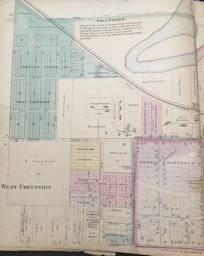
Northern
part of West Freeport
in the 1894 Plat Book
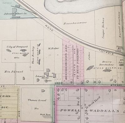
In the northwestern part of West Freeport is the Johnson Wheel Company, which manufactured wheels. The building later became the organ factory.
Just left of center is the Thomas Rockey Stone Quarry. Rockey was an early builder in Freeport, like his father, Paul. Thomas Rockey is probably best known for construction methods for mass-producing houses.
At the bottom left is the Thomas Grant Brick Yard, which covered a full 10 acres. His father, Thomas Grant, Sr., brought the family to Freeport in 1855 from County Louth, Ireland. During the Lincoln-Douglas debate time, 14-year-old Thomas, Jr., and his brother Patrick, 13, sold apples, pies and cakes to the thousands of visitors for the event, and made an astounding amount of money, $105, worth about $3500 today. When they grew up they owned the brick yard, stone quarries and a lime kiln. The brick yard shown operated from 1871 to 1906.
At the bottom right, where it just says Brick Yard was Trunck's brick yard. George Trunck started the business in 1852 and was joined by sons Frank and Charles in 1869. They made two million bricks per year, employing 15-20 men.
William Ascher also owned several quarries, in business from 1886 to 1919. He was the contractor who built the Civil War monument next to the court house. He also had a coal yard on E. Stephenson Street. He built many rental houses near the Illinois Central roundhouse, an area that came to be called Ascherville. Every Christmas he had an open house where everyone could bring their children for free candy and toys. He never ran out of candy!
At the far right, just north of the railroad tracks is the Burrell Brothers Vinegar Factory. The Burrell brothers moved to Freeport from Westmoreland County, Pennsylvania, in 1850. Henry worked for a few years as a tinner, then served for two years with the Union Army in the Civil War. After the war he went into the grocery business with his brothers, Louis and Daniel. In 1890, they closed the grocery and Henry and Daniel opened the vinegar factory.
And in the center of the map is the Schmich Brothers Brewing Company. The Western Brewery was founded in 1864 by Michael and Mathias Steffen, Freeport residents since 1853. They built two massive stone buildings, each 40 feet by 100 feet, and two stories high. They produced about 600 barrels of beer per year. In 1879, the Steffens sold their interest to Michael Huber. In 1880 Matt Schmich purchased an interest in the old Western Brewery, and ran it with Michael Huber.
In 1887, Matt's brother George bought out Michael Huber and it became the Schmich Brothers Brewing Company. They produced Rochester and Export bottled beer, and did so well that they decided to expand and build a new brewery on north side of Stephenson Street just east of the Pecatonica River. They built a four and five-story building with the newest equipment and planned to open the new brewery in January of 1897. Harvey Wilhelm wrote a book called, "Brewing in the Pretzel City" which covers this brewery and others in much greater detail.
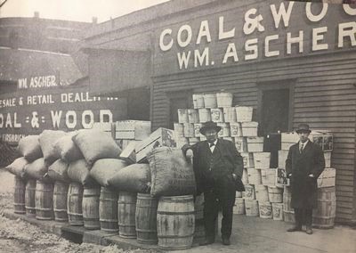
Freeport's own Santa Claus, William Ascher, center, with his assistant, John Place, standing with Christmas presents for all of Freeport's children. Every year he gave away barrels, bags, buckets and crates of apples, peanuts, oranges and candy.
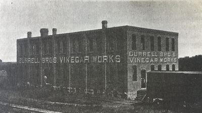
The Burrell Brothers Vinegar Factory produced 150 barrels of vinegar every day. (A fluid barrel is 31.5 gallons, so that's 4725 gallons of vinegar every day!) They had 40 vats that held 60 to 100 barrels each in various stages of production. They had machinery for grinding corn and rye, a Reedy industrial elevator for moving product between floors and a Ries 30-horsepower engine to move fluids around the factory. They produced high-quality cider vinegar and white wine vinegar.
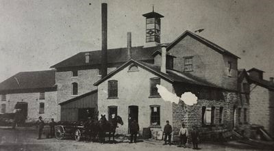
The Western Brewery became the Schmich Brothers Brewery, and after the Schmich brewery moved downtown, the buildings were used as a condensed milk factory.
Southern
part of West Freeport
in the 1894 Plat Book
Note that there are few houses in West Freeport. There were only about 35 homes in 1894, mostly wealthy people who fought annexation to Freeport, even winning a lawsuit to prevent annexation once. The main reason was money; they didn't want to pay Freeport's higher taxes, even though they enjoyed many of Freeport's amenities. There were many farms and orchards in West Freeport, many lots platted, but not many streets yet.
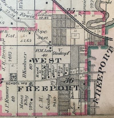
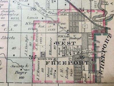
West Freeport
West Freeport was not an incorporated village; it had a village board that operated much like a homeowners association does today. There was no downtown, no city hall, no water or sewer, and no stores. In the 1894 Plat Book it did not even earn its own page; the map shown here is a close-up of the southeast corner of Harlem Township.
Above the "R" in West Freeport is rural school #5.
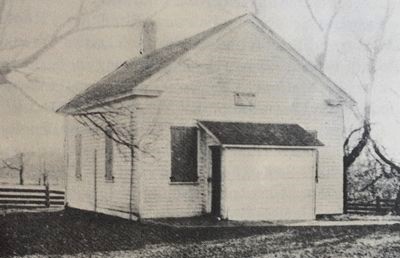
Rural School #5, The White School
The White School stood at the southwest corner of Stephenson and Globe/Park Boulevard. It was the first rural school to close.
When West Freeport and Freeport combined in 1907, it became part of the Freeport school system.
That corner later was the site of Highland Park. There is now a nice house at that corner.
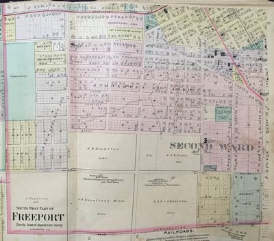
The Southwest Part of Freeport in 1894
In 1894, the western boundary of Freeport was in line with Whistler Avenue, and the southern boundary was in line with Cleveland Street.
The property that 30 years later was to become Freeport High School was 25.19 acres owned by H. W. Knowlton. The block that 60 years later was to hold Freeport Junior High School was owned by A. K. Knowlton's Heirs, and held just one residence, H. R. Cotta, proprietor of Stephenson County Nursery and Fruit Farm.
Across S. Walnut Avenue from St. Francis Hospital was the office of Freeport Nursery. And the block that was later to have Blackhawk Elementary School was the office of Lebkicher and Spitler, proprietors of Commercial Nursery and Fruit Farm.
Spring Creek is shown meandering from the area of the future Read Park northeast to downtown, where it entered a series of tunnels. A branch is also shown originating south of Grant/Moseley Street just west of S. Blackhawk Avenue.
Just west of S. Galena Avenue is Freeport High School, and west of that is the German Catholic Church and the Sisters School.
In the yellow-shaded downtown, there are labeled churches, the Galloway & Snooks pop factory on Walnut, the Mayer wagon works on Galena, a machine shop on Van Buren, and the Henney Buggy Company with a railroad spur going through the middle of the factory.
The Crotty brothers (possibly William Crotty and A. Crotty) opened the first pop factory in Freeport before the Civil War, then sold it to Galloway & Snooks in 1868. Joseph N. Galloway (1847-1892) and W. H. Snooks (1838-1917) produced carbonized beverages in Freeport until 1908, when Snooks sold the business to Schmich & Wilson, and it was operated by John Schmich. Galloway and Snooks married the Snyder sisters, Mary Jane (1840-1919) and Sarah (1842-1906), of Ohio. Sarah Snooks was known for her charitable works.
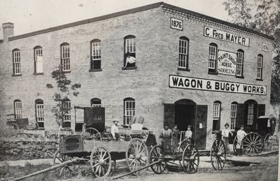
The C. Fred Mayer Wagon and Buggy Works was established in 1876 and was located on the west side of the 200 block of S. Galena Avenue.
C. Fred Mayer (1834-1912), a blacksmith by trade, first started in business in 1858, and retired from the business in 1888, though the business carried on without him for some time.
The sign in the front center of the building says, "Paint Shop & Horse Shoeing."
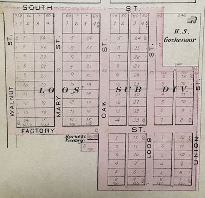
Loos Subdivision with the Loos Harness Factory
John Loos (1840-1908) and Nicholas B. Loos (1847-1915) came from Luxembourg to America in 1852, and to Freeport in 1862. They had businesses on Galena and Stephenson in 1880. They prospered and by 1894 they bought land south of South Street and east of Walnut Avenue. They manufactured and sold harnesses, saddles, trunks, suitcases and hardware.
John and his wife Mary had eight children. I presume he named Mary Street after her. Mary Street is now S. Cedar Avenue, and Loos Street is now S. Highland Avenue. Union Street is now S. Chicago Avenue. The site of the harness factory is now a lightly wooded lot on Factory Street.
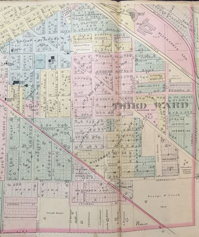
Southern
part of Freeport
in the 1894 Plat Book
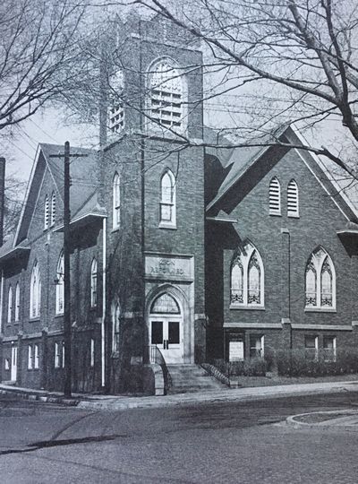
Starting at left center is St. Johannes Evangelical Church at Galena and Union/Chicago, then St. Mary's Catholic Church and school, Emmanuel German Evangelical Church and school, and 1st Reformed Church.
The Freeport Electric Railway streetcar line runs east on Iroquois, then south on Carroll where it terminates at Galena.
Just east of there is the Wright-Purinton Park, Third Ward School, and Fire House #2.
In the northeast corner of the Plat map is the Illinois Central Roundhouse and Shops.
The eastern boundary of Freeport in 1894 was in line with Clinton Place and S. Armstrong Avenue, while the southern boundary was in line with Cleveland Street.
In the southeast corner of Freeport was L. Bauscher's Freeport Market Garden.
I can see the house I grew up in at 1319 S. Carroll Avenue. It's the house just to the left of the "A" in Rice's Add.
The Oscar Taylor estate is not shown; instead it shows a newly platted street and house lots which never got built. The Oscar Taylor estate is now the Stephenson County Museum.
And across Carroll to the east is the Joseph Porter home and land, which has an amazing history.
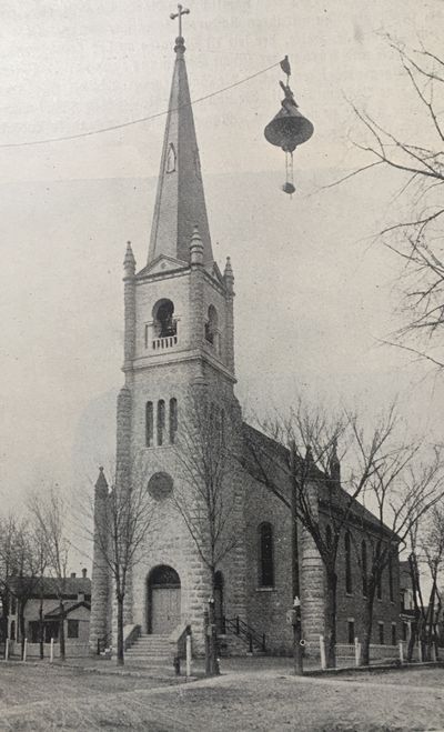
St.
Johannes Evangelical Church
at Galena and Chicago
It was a German-speaking church for many decades. It became St. John's Evangelical and Reformed, and even later, St. John's United Church of Christ. This building was built in 1865, burned in 1957, and the congregation built a new building at 1010 S. Park Boulevard.
Note the early street lamp, and the multiple hitching posts.
The first church building, St. Johannes Gemeinde, was built in 1850, but was outgrown in a year.
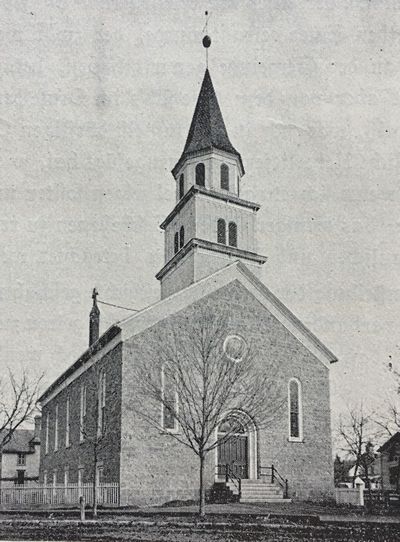
The second building was erected and lasted until the 1865 structure was built.
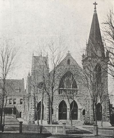
St.
Mary's Catholic Church
at 704 S. State Avenue
The church was organized in 1846. The first church was built in 1854, and this, the second, in 1890.
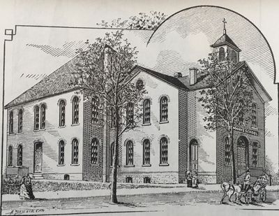
St.
Mary's Catholic School
across State Street from the church
St. Mary's School began in 1868. The St. Mary parish purchased the former English and German School building at 605 S. State Avenue in 1871. This is how the building appeared until 1897, when it was renovated, enlarged, and a third story was added. A fire destroyed the school on December 15, 1956. A 14-year-old sixth-grade boy admitted to starting the fire.
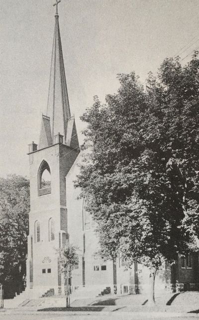
Immanuel
German Evangelical Church
on Union/Chicago at E. Pleasant
The
first church was built in 1877, the second in 1886. This 1900 building
is still standing, minus the tallest part of the steeple.
Immanuel Evangelical
Lutheran School
on Union/Chicago at W. Pleasant
The first building was where St. Mary's school was on State Street. The first building at this location was in 1877. This was the newer building, dating to 1923. I don't have a photo of the older building.
The church listed on the 1894 Plat Map at Iroquois and Chicago as the 1st Reformed Church was organized in 1862 as the First German Reformed Church. The first building was built in 1865, and the second, shown on this Plat, in 1879.
The building in this photo was built in 1927. It was Zion UCC for many years. I don't have a photo of either of the first two buildings.
Note the brick streets.
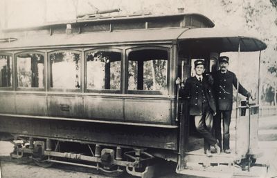
The Freeport Electric Company railway started in 1894. This is car number 2. With the first few cars, the motormen stood out in the elements. When winter came, they added enclosed cars, and these open cars continued in use in the warmer months.
The car barn was at the western edge of Taylor's Park, and lines ran west on Stephenson, northwest on Galena, and south on Carroll to Galena. It was very popular, and was soon expanded to include other areas of Freeport.
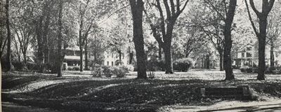
Wright-Purinton Park is Freeport's oldest park. Early Freeport developers O. H. Wright and judge George Purinton gifted the square block to the city in 1849, when 14-year-old Freeport had a population of just 1020.
Wealthy Freeporters rushed to build houses facing the park. It had nice landscaping, a fountain, flowers, a bandstand, a children's playground, and, eventually, a shelter house with restrooms. Located at Carroll and Iroquois, it later became known as Third Ward Park.
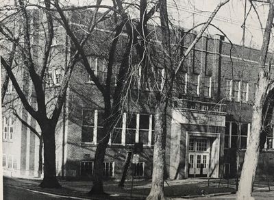
Third Ward School was located at Liberty and Iroquois, just east of Wright-Purinton Park. Built in 1865-66, it was commonly known as Wright School. This area of Freeport was growing rapidly, so the school was built to hold 500 students.
In 1894, the year of this Plat Book, the principal was Miss S. R. Barnes.
This building burned on November 21, 1926, leaving the walls standing. It was rebuilt in 1927 with new windows, floors, roof and face brick. The newly rebuilt building was renamed the John W. Henney School, in memory of a longtime resident of the area and a one-time member of the Freeport Board of Education.

Freeport Fire Station #2 is located at Adams and Iroquois. It was built in 1892 and housed four men, a hose wagon, and two horses.
Horses were used at this firehouse until 1913.
It took special horses to be fire horses. It took a lot of training. They were kept and fed in stalls, but had to be ready at all times of the day and night. When the fire bell rang, the horses would run to the front of the hose wagon, slip into their harnesses, then run at full gallop to the site of the fire. Some horses loved it, and worked 15 years before being put out to pasture.
With the advent of the telephone, some horses would run to the wagon every time the phone rang, whether it was a fire or not!
A new fire station was built at the same location in 1959.
The repair shops of the Illinois Central Railroad (IC).
The IC was the second railroad to come to Freeport, after the Galena and Chicago Union Railroad opened to traffic in 1853, shortening the trip to Chicago to six hours from two days. (Ironically, the Galena and Chicago railroad only laid tracks from Chicago to Freeport, and never made it to Galena!)
The Illinois Central was chartered in February of 1851 to build tracks from Cairo to Dunleith (now East Dubuque) through LaSalle, Dixon and Freeport. This was their first track.
The IC was the first land-grant railroad. In return for building out, the railroad was granted six sections of land per mile of track they laid, and had to pay no property taxes; they did have to pay 7% of their gross revenue to the State of Illinois. A section of land is a square mile, or 640 acres, so for each mile of track they built, the IC, a private company, was given, tax-free, 3840 acres of land.
The line west to Galena was completed in 1854, and the line south to Cairo was completed in 1856. By 1856, the IC was the largest railroad in the world, with the most miles of track. Freeport became a major railroad hub for passengers and freight.
The IC passenger station was built along the river just south of Stephenson Street, a plain wood building with ticket office, waiting rooms, and restaurant, plus a woodhouse and water tank for steam locomotives. In 1890 the brick building we are all familiar with was built in the same location.
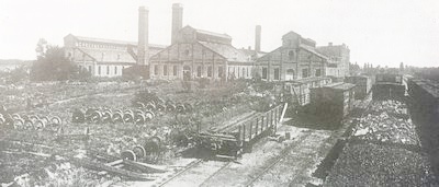
In 1886, the IC bought the Freeport Malleable Iron Works property and buildings southeast of the station for its repair shop and yards, shown here. Five hundred men were employed building and repairing cars, and servicing locomotives. Including all employees, the IC at one time employed 1200 Freeporters!
Lincoln and Douglas were both Illinois Central men. Both lobbied for the railroad. Douglas owned land near the Chicago terminal, and Lincoln was an attorney, with the IC being one of his clients.
These shops were removed in the 1960s. And the train most Freeporters identify with, the Land O' Corn, was discontinued in 1967. The Canadian National Railway acquired control of the IC in 1998.
In the 1894 Plat Book, Louis Bauscher (1857-1935) owned the Freeport Market Garden at Adams and Bauscher. The Freeport Market Garden sold flowers, plants, seeds and vegetables year-round from their gardens and greenhouses. Louis Bauscher started the business in 1883, and ran it under that name until 1926, when he changed it to Sunny Slope Gardens. He ran Sunny Slope until 1929, when he retired at the age of 72.
In 1926 Bauscher grew a strawberry so large it was displayed in Emerick and Ringer's Jewelry store. It was 3-1/2 inches in diameter and weighed 1-3/4 ounces, weighed on the jeweler's scale. It was grown at Bauscher's Sunny Slope Garden at 1110 S. Adams.
Louis Bauscher was a third ward alderman in the late 1890s and early 1900s, and helped to clean up and beautify Freeport. He was also instrumental in landscaping City Cemetery. He served for many years as an assistant supervisor for Freeport Township.
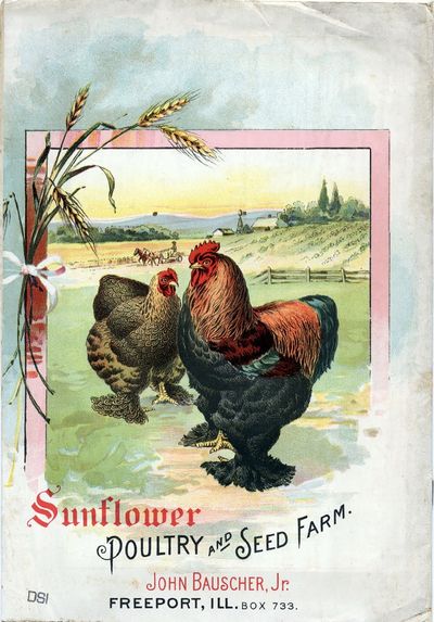
The seed catalog shown here was from John Bauscher, Jr., in 1898. John Bauscher, Jr., (1863-1920) had gardens on Adams and a flower store downtown on Chicago Avenue.
Members of the Bauscher family have had gardens, greenhouses and flower shops in and near Freeport since 1868.
One of my classmates from the great Class of 1966 recently asked me what I thought were the reasons for the decline in Freeport, and I wanted to reply so that all can see. The answer is not political, like many believe, but rather practical, and we are all a part of it.
I wrote recently about the Illinois Central Railroad, and how Freeport was a major hub. Other railroads also came to Freeport, so starting in the 1850s, entrepreneurs and manufacturing concerns were attracted to Freeport because they could have a rail spur to their factory where raw materials could be unloaded directly into the factory, and finished goods could be loaded to be shipped anywhere.
I've posted about various factories like Burrell Vinegar, Stover, Johnson Wheel, Keene Canning, Dirksen and Towlee, Tri-Angle, even Freeport Casket Company, who all had rail spurs to their factories. Henney Buggy had two, one running down the alley into the middle of the factory, and later a second running down the north side of Jackson Street.
Freeport offered great transportation of goods, and it drew business and industry.
Then automobiles came along, and people demanded better roads. The assembly line made cars affordable to most people. Eisenhower designed the interstate highway system, and got it built. Freeport, not a major population center, was left out. Interstate 90 came west out of Chicago to Rockford, then turned north to Madison. Interstate 80 went southwest out of Chicago to the quad cities and Des Moines. Freeport, after much lobbying, got a four-lane highway from Rockford.
With a great highway system, the trucking industry exploded. It became cheaper to use semi-trucks to move raw materials and goods than to use railroads, which limited shipping to being near the tracks, and if not near, then the added expense of offloading to a truck to the factory. Freeport, like other rail hubs without large populations, got left behind.
Stores liked malls, because there was shared free parking, then shoppers could go door-to-door inside no matter what the weather. Shopping malls killed downtowns. Big box stores could be built cheaply on less expensive land near a city's edge, and chain stores got better deals than small local stores, and could sell goods cheaper.
Then came the internet. Now we can buy anything and get it shipped directly to our door. Malls and box stores can't compete.
So who is to blame for Freeport's decline? We all are. We bought at Walmart for the prices, and the small mom-and-pop stores suffered. We bought on-line and made the malls struggle. Entrepreneurs who had been attracted to Freeport for shipping, could now set up shop in more attractive areas because of trucks and good highways.
And Freeport's people, its true treasure, could elect to stay because of all the great amenities there, or could move to an area that more suited their needs and wants.
So no, it's not political. It's progress. And we all participate.
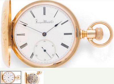
Freeport Watch Company
Hey, everybody, look in your junk drawers for an old pocket watch from the Freeport Watch Company. I’ll pay $100 for one in any condition! I’d love to have one in my collection of Freeport memorabilia.
In 1873 Eber Ward came to Freeport looking for investors to help him build a watch factory. He raised about $110,000 (worth about $2,000,000 today), bought 16 acres just east of the Taylor estate (now the Stephenson County Museum) and built a two-story brick factory on S. High Avenue.
He bought equipment from an old watch manufacturer in Michigan, and materials to make about 600 watches. He hired workers and taught his new employees the skills to build high-quality pocket watches.
All of the Freeport Watch Company’s watches were hand-assembled to the highest standards, and were known by the designer’s name, the Hoyt Watch.
The first 14 watches were made, each with their own serial number, starting with 1. One was presented to each of the 12 original investors who were on the Board of Directors, and the other two were kept by Eber Ward and his manager.
The next 400 watches were in various stages of production.
Then, on the night of October 21, 1875, there was a devastating fire in the building. Because the building was on the highest point of S. High Avenue, the flames were visible for many miles.
The building was completely destroyed. The entire inventory of 400 nearly finished watches, parts for the next 200 watches, and all the equipment was lost.
The building, equipment and inventory were only insured for $30,000 — just a fraction of the $150,000 value.
Investors were outraged and Eber Ward and his manager were indicted for arson.
The trial took place on Christmas Day, 1875.
The jury heard the evidence, and wanting to get home for Christmas dinner, quickly acquitted the pair.
The factory was never rebuilt.
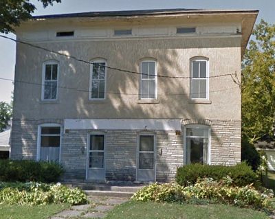
The Joseph Porter home on S. High Avenue
The Freeport Watch Company
Part Two
In Part One we saw one of the watches, learned a little about the factory, and heard about the fire that destroyed the building and contents.
After being put on trial for arson and being acquitted, Eber Ward moved on from Freeport and made more watches somewhere else.
The entire insides of the building burned and one or two of the brick walls came tumbling down. A century later some of the people who lived on S. High Avenue reported finding bricks when they dug in their yards and gardens.
In 1878 Joseph Porter (1825-1895), a retired farmer from LaSalle County, bought the 16 acres of land and the watch factory ruins. One report says that he tore down the ruins, and another report says that he used two of the remaining walls to build his home.
The Porter home is shown on the 1894 Plat Book, and is now a duplex at 1432 S. High Avenue.
And the watches? Of the 14 originally made, only 5 are known to have survived. So you might just have one in a drawer or in a box that grandma gave you.
If you have one, take good care of it. A few years ago serial numbers 1 & 2 sold at Sotheby’s Auction House for $48,000 and $58,000. Just a watch face (the part with the numbers) is available now on eBay for $1000.
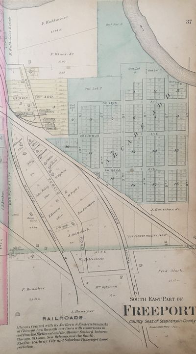
Southeastern
part of Freeport
in the 1894 Plat Book
In the southeast part of Freeport we can see the various farms of the Bauscher Family. On the far right is the "Sun Flower Poultry Farm" of John Bauscher, Jr. -- I posted the cover of his catalog above.
There are a few houses on Public Road (now S. Arcade Avenue).
The Arcade neighborhood is platted out, but there are no houses yet.
There are some businesses at Gund and Columbus (now Hancock & Shawnee), which I will cover below, and a few scattered houses and farms.
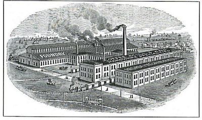
The Arcade Manufacturing
Company
marked Foundry - Coffee Mill in the 1894 Plat Book
note the two rail spurs leading into the factory
and the Electric Railway that brought workers to the plant
In 1868, brothers Charles (1852-1920) and Edgar (1848-1928) Morgan started a factory in two brick buildings on the corner of Chicago and Jackson, and employed ten people making plows and pump castings. By 1872 it was called the Novelty Iron and Brass Foundry, with J. B. Hazen and E. H. Morgan listed as owners. Hazen and the Morgans were related.
In 1874, they were known as Hazen and Morgan Bros. They tore down the buildings and built a new factory in the same location with a foundry, machine shop, and engine room. By 1875, it was called Novelty Iron Works, making cast iron products like pumps, windmills, feed grinders and ornamental iron.
In 1884, it was no longer Novelty Iron Works. A new business was there, called The New Union Manufacturing Company. They made their first box coffee mill and a spice mill, their only two products at this point.
The company struggled financially and went out of business in 1885.
The Morgan brothers patented a cork puller, and Albert Baumgarten, who owned a very successful bar and pool hall, purchased the patent and invested with the Morgan brothers in 1885 to start a new company in the same factory, with the same equipment, and they called the new business Arcade Manufacturing Company.
In 1888 Arcade made a toy coffee mill that was very successful.
The company prospered and outgrew the buildings, so in 1891 Arcade bought the building formerly owned and used by William H. Emery and J. D. Williams Canning Company before they merged with Fremont Keene's Canning Company.
On July 24, 1892, the buildings at the new location burned to the ground. Everything burned, including all their new equipment, all their raw materials, and their warehouse with 40,000 new coffee mills waiting to be shipped!
In 1893, Arcade brought in a new investor, Loyal L. Munn, Sr. (1829-1908), and built the factory at their new location at the northeast corner of Gund (Hancock) and Columbus (Shawnee), on land that was formerly part of the Keller-Wittbecker farm.
In 1894, Charles Morgan patented a coffee mill, and the company began manufacturing them. Charles Morgan continued to design coffee mills, and the mills were Arcade's best sellers.
There was lots of scrap metal involved in the casting of the metal parts of the mills, and some of the workers played around with it and made some metal toys, which they initially gave to their children. The children loved them, and by 1908, Arcade was making metal banks with horses, lions, seals, pigs, buffalo, cows, rhinoceroses and rats.
By the 1920s, toys were by far the most profitable line of goods that Arcade made; the other major products were household hardware specialties, molding machines, and cast brass and bronze refrigerator hardware. They advertised nationally and set up permanent showrooms in Chicago and New York.
Arcade made specialty items: the Red Goose Bank for Red Goose Children's Shoes, an Avery tractor, the Buster Brown jack set, The Yellow Cab, the Fordson tractor, the Andy Gump car, the Oliver plow, the W. & K. truck trailer, and International Harvester trucks.
In 1929 Arcade added a ten-foot dollhouse with toy appliances and furniture, and even electric lights! They gambled that making realistic toys would appeal to children, and they were wildly successful.
Also in 1929 they created a storybook featuring the Tiny Arcadians, fantasy story folk who created toys for children who had none. They gave the book away to anyone who asked for it.
In 1933 Arcade designed a line of toys specifically for the Chicago Century of Progress World Fair. In 1935 they made Greyhound buses for the Dionne Quintuplets.
They manufactured three lines of tools: Arcade Craft Tools, Craftmaster Tools, and Homecraft Woodworking Tools.
During World War Two, the company made armor plating.
Rockwell bought Arcade in 1945, and closed the factory in 1953.
Arcade invented, patented and manufactured its own molding machines, making casting faster and more efficient. They made casting machines for other companies and sold them world-wide. Rockwell bought Arcade to have access to these patents, and put hundreds of Freeporters out of work when they shut down the factory.
Before his death in 1928, Edgar Morgan hired Chicago sculptor Emory Seidel (1881-1954) to design a memorial fountain behind the tennis courts in Read Park. It is there still, and includes a statue of children playing.
So how did the Arcade get its name? Remember Albert Baumgarten who infused a lot of capital into the company in 1885? He had a very successful bar and pool hall that was called The Arcade!
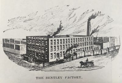
The Bentley Factory
on Gund/Hancock
The property immediately north of Arcade Manufacturing is listed on the 1894 Plat map as Piano Stool Factory.
Henry Dinsley Bentley was born in London, England on December 6, 1848. His parents brought him to Freeport in 1851. He attended Freeport schools and worked for a time for William Walton in the dry goods department, but his real interest was music. Bentley later gave credit to Walton for teaching him business sense.
He moved to Chicago and was employed for five years with Pelton and Pomeroy, who at that time were the largest piano and organ dealers in Chicago.
In 1878 Henry Bentley opened a music store at 144 Stephenson Street in Freeport. He sold musical instruments and sheet music. He began building organs and selling piano and organ stools. The stool part of the business took off. By 1883 he was selling 100 stools per day. He contracted with Woodmanse & Hewitt, a Freeport manufacturer, to build stools for him.
In 1891 he built a factory on Manufacturers Island to make his own piano stools, and quickly outgrew the plant.
In 1893 he built the factory shown here, with a Chicago, Milwaukee and St. Paul rail spur for raw materials and finished goods, and passenger service for his employees from the Freeport Electric Railway. The H. D. Bentley Piano and Organ Stool factory produced 1000 stools per week in a hundred different styles. He sold stools in every state in the union.
With piano stools the most successful line of sales, he also manufactured and sold hundreds of Bentley organs. He published books, the Bentley Methods of Instruction for both piano and organ, publications that were used by music teachers.
In 1875 Henry married Ellida Patterson (1856-1946), an 1873 graduate of Freeport High School.
Ellida Bentley was president of the Woman's Club and decided that Freeport should have its first celebration of the famed Lincoln-Douglas debate on its 45th anniversary in 1903.
Originally the idea of Mrs. Robert Hall Wiles in 1897, and promoted by Mrs. Charles Hildreth (in those days married women were referred to by their husbands names!), nothing had actually been done. Ellida got the ball rolling, with the help of Flora Guiteau, Winnie Taylor, and others.
The Woman's Club bought a large boulder and had it shipped to Freeport from Devil's Lake, Wisconsin. Ellida had the idea that it would be nice if the President of the United States would come to Freeport for the dedication of the memorial.
She asked Dr. J. D. Fair, president of the Stephenson County Republican Club to invite President Theodore Roosevelt.
To everyone's surprise, the President agreed, but could come in June instead of August.
The Woman's Club had a plaque made and had it attached to the six-ton boulder. After much discussion, the granite boulder was placed at the corner of Mechanic/State and Clay/Douglas.
The Woman's Club asked William D. Wright to chair the event and to coordinate with the Secret Service for the President's security.
Merchants were asked to decorate downtown. A parade route was chosen, and boys and girls were lined up alongside the route so that the children could witness "the most distinguished citizen of the U. S."
Souvenirs were made to be sold. The Henney Band was asked to play. A baseball game was planned for after the President left.
All the factories shut down and were asked to blow their whistles when the President's train arrived.
Everything was all set on Wednesday, June 3, 1903.
Then it rained.
President Roosevelt arrived by train, went by car to the boulder dedication, spoke briefly, and was taken to the courthouse to give a speech. All of Stephenson County's dignitaries were there.
President Roosevelt gave some brief remarks, then left for the train station.
President Theodore Roosevelt, the only President to visit Freeport while in office, spent 25 minutes in Freeport, then left.
Henry and Ellida's son Charles was Freeport's police magistrate, and son Henry, Jr., helped with the stool business. Henry Bentley, Sr., died of Bright's Disease on December 24, 1904, at the age of 56.
Henry's sister Lizzie (1845-1921), FHS Class of 1863, was a music teacher in Freeport.
The family closed the factory and sold off all the inventory in 1905.
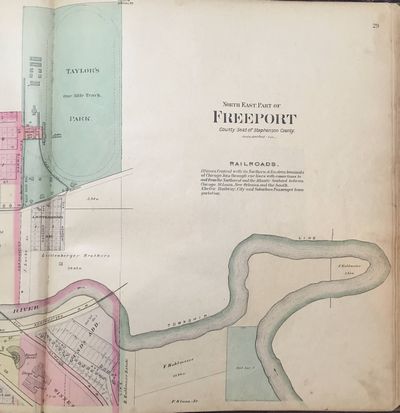
Northeastern
part of Freeport
in the 1894 Plat Book
In 1894, northeast Freeport had little development.
At the bottom left is the Illinois Central roundhouse and shops. I already posted the shops.
Just east of there is Ascherville. Gund/Hancock doesn't cross the river; the bridge wasn't built for horse & pedestrian traffic until 1895, when the Electric Railway tracks needed to cross the Pecatonica River.
And in the far north is Taylor's Park, which I will write about more extensively.
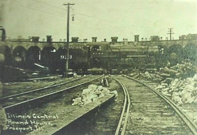
The Illinois Central
roundhouse in an undated photo,
shown with a steam locomotive and tender on the turntable.
The roundhouse was used to service and store locomotives. It was built in a semicircle, with a turntable in the center.
The locomotive and tender (holds the water for steam, and coal or wood for fuel) would disconnect from the rest of the train and pull onto the turntable. The turntable then rotated to a position where the engine could back into a slot in the roundhouse, effectively turning around in the smallest possible way; the roundhouse gave the workers the opportunity to service the engines out of the elements.
In 1894, locomotives were all steam powered, from burning either coal or wood. Steam locomotives were powerful moving forward, but had limited ability moving backward, thus the necessity for a turntable.
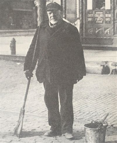
Charles Green (1826-1912)
With financial support from investors, John Butler Taylor (1831-1909) started the first street car company in Freeport in 1886. Charles Green (shown here cleaning up the poop!) and Johnnie Cannon were his drivers. The street cars ran on rails and were pulled by mules. In the winter, the mules pulled bobsleds over the snow and ice.
The first line ran west from Taylor's Driving Park on Taylor/Stephenson to Whistler Avenue, and the second ran south on Chicago, zigzagging east and south on Iroquois and Carroll to Galena.
The lines were very popular, and when the system went electric in 1894-1895, they added a line that ran north and west on Galena to the city limit, while the Carroll route was extended south to Empire where it turned east, then zigzagged out to the Arcade and back north on Gund/Hancock. The Gund/Hancock bridge was built in 1895, and that made a complete loop that was popular with families: a tour of Freeport for only 5 cents per person!
The Stephenson route was extended west to Highland Park, and, eventually, south to Krape Park.
The mule and car barns were on the west edge of Taylor's Driving Park; Taylor also pastured the mules on his 80 acres. When they electrified, a new two-track car barn was built at the corner of Liberty and Spring.
1894-1895 were the transition years, as Freeport switched from mules to electric. Charles Green's son William Green ran the first electric trolley car, and worked for over 20 years ferrying Freeporters around town. William Green's two brothers, Thomas and George, also became motormen.
The description in the various histories of Freeport alternately describe the early street cars as horse-drawn or mule-drawn. From what I can tell, Taylor tried draft horses and mules. Eventually he used mules because big draft horses were prone to lameness and chipped hooves. Plus they were very hungry. Mules, on the other hand, have great strength and stamina, are agile and athletic, can withstand heat and can travel long distances without water. They eat half as much food as horses, and can work for 30 years.
America's breeding stock of large working mules came from George Washington who imported breeding stock from Europe after the revolutionary war. Washington was a land speculator, and controlled 60,000 acres west of the Alleghenies in what is now West Virginia, Ohio and Western Pennsylvania. He knew that if America got its independence, he would become very wealthy, and to open up that territory to farmers and settlers, they needed mules, not horses. He built stables at Mt. Vernon, and by the time of his death in 1799, he had 60 working draft mules on his estate, with many more sold.
The job of every historian is to be as accurate as possible. Researching stories of people and events that occurred more than a hundred years ago, one has to depend on sources that sometimes contradict each other, that give different dates for an event, or even assume details that just didn't happen. This is the case with researching Freeport's early trolley system. I used seven different sources, and dates and details varied widely. What follows is a compilation of facts.
First discussed years earlier, investors eventually raised the money to buy the trolleys and horses, lay down four miles of track, and build the car barns and stables at Taylor's Driving Park. The streets were not yet paved, so laying track in the dirt was fairly simple. The first trolley ran on Thanksgiving Day, November 25, 1886. That day only, riding the trolley was free for children.
Each car could hold 20 passengers, with the driver standing on an open platform. Initially teams of horses were used to pull the trolleys, but a full load was difficult for the horses. For reasons I outlined above, they switched to teams of mules. The first cars were open, but soon a canvas top was added to keep off the sun and rain. When winter came, closed cars were added, with a charcoal stove to heat the trolley. The horses and mules each had a bell on their collar to warn pedestrians of the approaching trolley. Benches were placed at both ends of each line for waiting passengers.
Some of Freeport's finest citizens complained that riding behind mules was "a disgrace to human dignity," so the system reverted back to horses.
Discussions to convert the system to an electric railway started in 1892. But that meant new investors for overhead electric lines, new motorized cars, a new car barn, and new, heavier rails for the heavier trolleys.
On December 1, 1894, the new electric trolleys started to run. The horse- and mule-drawn trolleys lasted just eight years.
In the 1894 Plat Book, all the routes started at the car barn, and were named after their first terminus. The first route was straight up Taylor/Stephenson to its terminus near Whistler. It's interesting that it terminated in the City of Freeport and did not extend into the village of West Freeport. This route was the Stephenson line. I wrote the story about Freeport/West Freeport above.
The second route again started at the car barn, went west on Taylor/Stephenson, turned south on Chicago, east on Iroquois, then south on Carroll, first terminating at Galena, then later terminating at Empire. This was the Carroll line.
The 1894 Plat book also shows the Carroll route extending north on Chicago to Oak Place/Linden, going west on Galena terminating at Whistler, again at the city limits. I'm not aware that this was ever used with horses/mules; it appears to be a new line for the electric cars starting in December 1894.
On the Stephenson and Carroll lines, when they reached the end they had to unhitch the team and re-hitch at the other end of the trolley car to go back downtown on the rails.
When they electrified, they extended the Carroll route east on Empire, ending at Hancock and Taylor, making a complete loop, always going counterclockwise.
Here's what Fulwider had to say in his 1910 History: "...building the extension in the southeastern portion of the city, which is known to Freeporters as "the loop." The Loop Line runs east from the old Carroll street terminal at Empire street to Bauscher street, north on Bauscher street to Adams street, northwest on Adams street to Chippewa street, north on Chippewa street to Shawnee street, east on Shawnee street to Gund avenue, north and west on Gund avenue to Hancock avenue, north on Hancock avenue to Taylor avenue, connecting with the East Stephenson street line of the company. The building of this line helped to open up the Arcade addition, and other parts of the city, which were formerly altogether without transportation facilities."
The 1913 Plat Book shows the Stephenson line extending into Highland Park, and also turning south on Globe/Park, terminating just short of Globe/Krape Park, close to Dr. Snyder's home and the Freeport Country Club, all three outside the city limits in 1913. I wrote about Dr. Snyder on my 1913 page.
The Homer line is not shown in the 1913 Plat Book. From its name, it apparently terminated on Homer, but I don't know what route it took to get there. If I ever find the route of the Homer line, I'll post it.
Also not in the 1913 Plat Book is the car barn and the tracks to it.
The electric trolleys were very popular. In 1920, there were 1,869,598 paid fares. Then the automobile began to take over, and just like train travel became less important, ridership on the trolleys declined sharply. The last electric trolley ran on October 21, 1933, ending a 47 year run. Eight days later, Freeport's first buses started service.
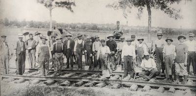
The photo shown here was taken August 12, 1913. The photographer was standing in front of what is now the location of St. John Church, looking east toward Freeport. There are two church steeples visible in the distance. The fields just behind the men were part of Pleasant Home Farm, belonging to C. M. Saxby.
These workers are laying track on Globe Avenue, now Park Boulevard. This section of track went from the corner of Stephenson and Globe to the entrance of Globe/Krape Park. The plat map showing the terminus of the line is below. The only man identified in the photo is the gentleman in the white hat, second from left, William Green, Superintendent. His father, Charles Green, was the subject of my post above. Behind the men on the left, just in front of the tree, is Birdie, the horse used to pull the wagon with with rails and ties up from downtown. Birdie was one of the horses used before the system was electrified in 1894-1895.
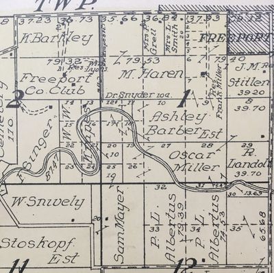
This is the northeast portion of Florence Township. The dashed horizontal line at the top is W. Empire St./Pearl City Road. The trolley line is shown at the top left, terminating just at the northern border of the land belonging to W. W. Krape.
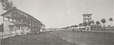
Taylor's
Driving Park
1888 photo
XOX
Northern
part of Freeport
in the 1894 Plat Book
..
Click
on any year in the chart below to see the class and other info,
such as postcards, people and events from that year.
|
1894
|
|||||||||
| 2010 | 2011 | 2012 | 2013 | 2014 | 2015 | 2016 | 2017 | 2018 | 2019 |
.